ROVs provide a unique opportunity to explore beneath the frozen surface
Svalbard is subject to all types of research, both on land and below the ice. Scientists from the Norwegian University of Science and Technology (NTNU) have for many years collaborated with the University Centre in Svalbard (UNIS) to understand more about the changes happening at Svalbard and how that relates to the changes happening to the rest of the Earth and temperatures rising.
During winter, the polar regions are covered by vast expanses of sea ice. Traditionally, this ice has been studied through in situ measurements and remote sensing (the technique of obtaining information about objects or areas from a distance) from airborne platforms and satellites. However, marine robotics now offer an innovative approach to exploring these icy environments from below the surface. Remotely Operated Vehicles (ROVs), in particular, provide access and versatility, revolutionizing the study of Arctic sea ice.
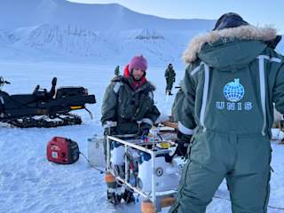
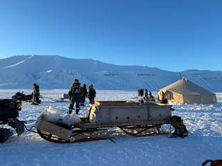
This winter, NTNU and UNIS had a unique opportunity to explore beneath the frozen surface. Their research at Svalbard centered on understanding the processes occurring below the ice and studying different sea ice features in Van Mijenfjorden, particularly during winter time.
I started to go to Svalbard twenty years ago, and some years I can not recognize it because it changed so much. - Martin Ludvigsen, Professor, NTNU.
Researching and developing navigation technology for specific Earth environments can provide valuable insight for exploring sub-surface structures beneath the sea ice. A crucial part of NTNU and UNIS's study was bringing along a double Blueye ROV configuration and a single Blueye ROV.

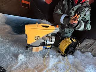
Blueye ROVs brought along to the mission at Svalbard
Conducting research in the Arctic demands extensive logistical planning and dependable equipment. Reliable tools are crucial because if any equipment fails, it could compromise the entire mission. However, advancing research requires the ongoing development of new methods and instruments. To tackle these challenges, NTNU and UNIS utilized the Blueye platform as their instruments, including a hyperspectral imager.
The Blueye ROVs are robust, user-friendly, and easy to maintain, making them suitable for withstanding various weather conditions. Therefore, these ROVs were well-suited for the mission in Svalbard. It is exciting to see that the Blueye underwater drones performed reliably throughout the entire stay in Svalbard, meeting the necessary standards and enabling the team to successfully complete their objectives.
The Blueye ROVs proved to be dependable in the cold conditions of Svalbard, while also being easily portable, lightweight, and quick to set up. It only takes a few minutes to connect with the Blueye App and deploy the ROV, making it an excellent tool for operations.
For us, the reliability of the Blueyes is very important for the expedition and the work we did up there. - Martin Ludvigsen, Professor, NTNU.
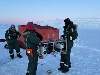
Two Blueye ROVs carrying one hyperspectral camera
The success of the fieldwork and research in Svalbard depended on the performance of the double Blueye ROV, housing the hyperspectral camera. NTNU and UNIS's engineering team integrated these components, deploying two Blueye ROVs to carry a single hyperspectral imager, enabling them to capture detailed images of the ice's underside. In addition to the double Blueye ROV, they included a third Blueye ROV to get a third-person perspective on the dual vehicle operations, enhancing their situational awareness and navigation capabilities.
The engineering team used Blueye's software development kit (SDK) to develop a control system that enables the simultaneous operation and steering of two underwater drones.
Furthermore, the third Blueye ROV was equipped with an Aqua TROLL multiparameter sensor to collect water temperature and salinity data. This information collected by the Aqua TROLL was essential for understanding ice mechanics, especially regarding the temperature of the water beneath the ice, its proximity to freezing, and whether the temperature was uniform or exhibited a consistent vertical gradient.
We saw that the ice was quite cold. Between -1 and -2 under the ice. From the ice down all the way to the sea bed. - Martin Ludvigsen, Professor, NTNU.

Hyperspectral camera
For the fieldwork in Svalbard, the hyperspectral imaging analysis primarily focused on visible light. A hyperspectral camera captures the full visible light spectrum, spanning from infrared to ultraviolet, in contrast with conventional cameras that combine red, green, and blue bands. This high-resolution color imaging enables the identification of various pigments, such as chlorophyll and beta carotene, which assists in species identification.
NTNU and UNIS have explored the application of this expanded color information to identify additional ice features. This research is especially relevant for navigating environments similar to those found on icy moons. NTNU and UNIS are at the forefront of engineering research, collaborating with NASA Jet Propulsion Laboratory (JPL). This partnership mainly focuses on exploring under-ice environments, driven by JPL's interest in the ice-covered moons of Jupiter and Saturn.
I think the research of observation is important to connect it to remote sensing. - Martin Ludvigsen, Professor, NTNU.

Next step of the research
Observing ice from space provides valuable data, but accurately estimating its thickness and the abundance of ice algae that grows beneath it remains a challenge. NTNU and UNIS can significantly enhance remote sensing data by utilizing hyperspectral imagery for precise measurements and correlating these with satellite imagery. This correlation is crucial for understanding and advancing sensor capabilities by applying hyperspectral imaging in various contexts.
After NTNU and UNIS had completed the research, they reviewed successes and areas for improvement. Future improvements include, among other things, using a DVL for navigation. Despite challenges, NTNU and UNIS achieved all objectives. Data processing and ice thickness estimation were discussed, highlighting the importance of spectral signatures and Aqua TROLL sensor data collected by the single Blueye ROV to enhance operations alongside the double Blueye ROV under the ice.


